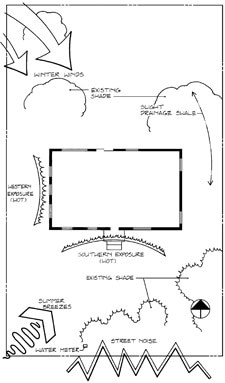
The image above is a simple map showing basic site analysis. Link to source.
Site Analysis is something most people overlook. Or, if they think about it, only do a quick analysis, then move on.
I’ve mentioned before Good Design uses your environment to shape the activity, feature or space. This is what separates cookie-cutter design from good design. It also makes your design unique.
No one else lives exactly where you live. Or experiences the conditions you do.
Let that history of the area influence your design.
What to Research
Site Analysis covers many items. We’ll explore the four main points and touch on each topic beneath them in extra posts over time. For now, I outline your focus under each point.
1. Local Weather & Climate (and how these change over different time scales)
Try to find the averages over a number of years for each of the following. Try to judge where you think the climate is heading into the future. Cover the extreme events. Knowing extremes means you can design and build for those levels – especially heavy rain, snow and wind. This ensures your garden can cope with those rare occasions.
- Wind
- Rain
- Sun
- Temperatures
- Extremes of these weather patterns
2. Surrounding (offsite) Impact
This draws on your knowledge of the site. Look around your garden and see where neighbouring items outside your property interact with your site. It may be through casting shadows, or falling leaves. It could be windows or outdoor spaces overlooking your garden. Can you see how they view your garden now? How about neighbouring noise you may want to block?
Shadows will change throughout the year. Try to see how they impact your garden at different times of the day, and different seasons. This will help you NOT place some programs in shaded areas, when you want them in sun.
- Neighbouring Trees/ Buildings/ Windows etc.
- Neighbouring Noise/ Other concerns (such as line of sight)
- Shadow Plans – different times of day, different seasons
3. Ground Conditions/ Spot Levels
Basics of your site. What is your soil like? Where is the highest point? Lowest point? Are there steep slopes or uneven ground? Do you have existing infrastructure like manholes or underground conduits for utilities? Mark these down where possible.
- Soil Conditions – Soil pH/ Texture
- High Points
- Low Points
- Slopes
- Utility Components/ Items below ground
4. Regulations
Most councils have rules around what can and can’t be built. Your house and property plan should outline restrictions such as easements. These are areas you cannot build permanent structures across. They often cover council infrastructure like storm water drains or sewerage. They must be uncovered so they can be accessed should that be necessary.
Some councils also have style restrictions on street fronts. To maintain a local theme. Or councils have flora and fauna guidelines, to prevent invasive species entering local areas. Check council websites for this information, particularly around flora. You will engage experts later on, who should also understand these regulations and restrictions.
- Council Restrictions
- Easements
- Local Style Regulations
This is a major part of potential site analysis. Learning how to garden design without doing this research will only waste time. And cause headaches later on.
I cover site analysis in more depth in my How To Garden Design Guide.
Presenting Site Analysis
Now that you have researched some of the above items, it’s time to present them in an easy to understand way.
Your site analysis will (hopefully) be visible next to your work area. We want this information at hand when you are designing. As I’ve said before, your site informs good design. Using wind, rain, sun, shadow, oversight, ground levels and seasons to shape your design means you need analysis nearby.
Let’s look at some simple graphical tips to show information:
- Hatching – to show shadows, slopes or ground types. Easy to change the density and quick to draw
- Lines – to show wind strengths and direction, to show water movement through site etc.
- Colours – to show materials, overlooking, climate conditions, areas, slopes etc.
You can use any combination of the above options for your analysis. Or do some quick research to see what you like. And what is easy to understand for you.
You won’t win any prizes with this work. It has to be simple for you to understand. And you want to be able to quickly glance at it and get the information you want.
Once you have some of this information in a simple format you can read easily, it’s time to start a basic design framework.
Have a look at some examples below. Click the images to go to source.

Working through you site analysis will help you understand your site better. You will uncover things you never noticed. And consider new ways to design on your site – using your environment, not in spite of it.
Take your time to work through this process. View it as an opportunity to learn more about your surroundings – and how to use them.


